|
|
RouteWriter 2.11
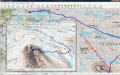
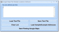
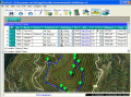
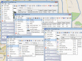
Imports and Exports MapPoint waypoints and pushpins in route-order. MapPoint always re-arranges pushpins when it does this. Exports routes directly to Excel, or you can create a route from pushpins in a pre-determined order.
free download trial (3.14 Mb)
|
|
|
GPS/J 2.8
GPS/J is a console for Bluetooth-enabled or built-in GPS receivers. It is a JME (Java Micro Edition) application for JSR82-compliant devices. Equipped with POI database and raster maps of any country, you can record and export tracks and waypoints.
free download trial (308 Kb)
|
|
|
Mapyx Quo 2.1.7
Mapyx Quo enables you to connect your GPS to your PC. View information - elevation, distance, speed, ETA,etc... Quo supports: GE KML,GPX format,ESRI SHP,Geocaching,Garmin,Magellan,OziExplorer files and more. Includes importing your own scanned maps.
free download (32 Mb)
|
|
|
|
|
OkMap 8.8.3
OkMap is a software that works with vectorial and raster maps that you have bought or scanned. OkMap lets you organize paths by creating waypoints, routes and tracks, and upload/download data to/from your GPS. OkMap supports GPS real-time navigation.
free download (20.21 Mb)
|
|
|
Google Maps Plot Multiple Locations Software 7.0
Map several addresses on one Google Map layout. Save results as image files.
free download trial (811 Kb)
|
|
|
HoudahGeo 4.0.1
One-stop photo geocoding for the Mac: Know where you took that photo. Write geotags to EXIF, XMP & IPTC. See your photos in Google Earth. GPS device optional. Use with iPhoto, Aperture or Lightroom
free download trial (17.64 Mb)
|
|
|
|
|
EdiTrail 1.0
Create/Edit/Display/Management/Import/Export Trails/Routes in a simple and flexible environment divided in a data table for the management of trails and a map resulting from numerous providers, (Bing, Arcgis, Ovi, Yahoo, etc).
free download (27.05 Mb)
|
|
|
Eye4Gps 2.1
GPS Mapping Software for Windows, Loading topographic maps, manage GPS devices and more. The software can be used with various map formats including: GeoTiff, BSB Nautical Charts, AutoCad DXF files, ESRI Shapefiles.
free download trial (19.03 Mb)
|
|
|
RoboGEO 5.6.20
Geotag photos from a GPS. Stamp the images or write to the EXIF headers. Export Google Maps, KML KMZ files for Google Earth, Shapefiles (SHP), AutoCAD DXF files, or Flickr. Import from tracklogs, waypoints, GPX or place names.
free download trial (9.28 Mb)
|
|
|
Eye4Gps GPS mapping software 3.0
GPS Mapping Software for Windows, Loading topographic maps, Realtime navigation and more. The software can be used with various map formats including: GeoTiff, OpenStreetMap XML, BSB Nautical Charts, AutoCad DXF files, ESRI Shapefiles and image files
free download trial (8.3 Mb)
|
|
Pages : 1 | 2
|
|
|
|