Mapyx Quo enables you to connect your GPS to your PC. View information - elevation, distance, speed, ETA,etc... Quo supports: GE KML,GPX format,ESRI SHP,Geocaching,Garmin,Magellan,OziExplorer files and more. Includes importing your own scanned maps.
The most accurate and handly Altimeter is here. It gives you the altitude wherever you are.Simply start the app and altitude will appear in a second, No setup required. You can also adjust Altitude in Feet or Meter as per your requirement.
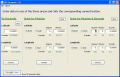
GPS Converter will convert GPS coordinates between three different formats: 34.26965, -116.76783; N 34?° 16.179', W 116?° 46.07'; and N 34?° 16' 10.74", W 116?° 46' 4.2". Will map the results in Google Maps.
DiskFresh is a simple yet powerful tool that can refresh your hard disk signal without changing its data by reading and writing each sector and hence making your disk more reliable for storage. It also informs you if there are any damaged/bad sectors
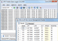
GPS Tracker Data Logger acts as the server and allows you to collect data from an unlimited number of various GPS trackers simultaneously. The obtained data is processed, uniformed and written to a log file or a database in real time.
Depending on your geographical location GPS-Action will fire alarm, open the application, change profile, launch the website, open a document or a certain application for you.All actions are performed without any user interaction.
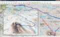
GPS Mapping Software for Windows, Loading topographic maps, Realtime navigation and more. The software can be used with various map formats including: GeoTiff, OpenStreetMap XML, BSB Nautical Charts, AutoCad DXF files, ESRI Shapefiles and image files
Forex Signal Services has consistently provided record breaking profits for several years now. Trading like the professionals do. Use 100% Automatic Forex Signals. THOUSANDS of predictions Daily. Findout Here: www.ForexSignalServices.info
AnyCoord allows you to simply change your GPS location to any virtual spot. It also offers three modes to enhance your experience: One-stop mode, Multi-stop mode, and Joystick mode.