HandyArchive.com
MapPoint templates for US State & County Maps

US State Mapping Template 1.0


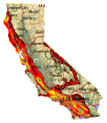
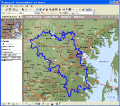
US State Mapping Template consists of Microsoft MapPoint templates that enable you to create maps of individual (or combined) US States and Counties. Supports MS MapPoint 2002 and later (North American Edition only).

free download trial (1.4 Mb)


Microsoft MapPoint Shape Name Tool

Shape Name Utility 1.0


Freeware add-in tool for Microsoft MapPoint. Allows a user to view a shape's name and modify it if necessary.

free download (1.19 Mb)


Import/Export MapPoint waypoints and pins

RouteWriter 2.11


Imports and Exports MapPoint waypoints and pushpins in route-order. MapPoint always re-arranges pushpins when it does this. Exports routes directly to Excel, or you can create a route from pushpins in a pre-determined order.

free download trial (3.14 Mb)


MapPoint templates for North American Maps

North American State Mapping Template 2.0


North American Mapping Templates consist of Microsoft MapPoint templates that enable you to create maps of individual (or combined) US States & Counties; and Canadian Provinces. Supports MS MapPoint 2002 and later (North American Edition only).

free download trial (1.4 Mb)


Shape manipulation tool for MS MapPoint

MPSuperShape 2.6


MPSuperShape is a shape manipulation tool for Microsoft MapPoint. MPSuperShape can combine shapes, find overlaps, find boundaries, and import/export various files. MapPoint 2006, .NET Framework 2.0 (or later), and Windows XP or Vista required.

free download trial (13.54 Mb)


Calculate Mileage Distances with MS MapPoint

MPMileage 1.6


Batch calculate distances, travel times, and/or costs for point-to-point routes listed in a database (Access, Excel, or ODBC). Uses MapPoint for point locations and route calculations. Supports all of MapPoint's route options.

free download trial (2.71 Mb)


Cluster analysis for Microsoft MapPoint

MPCluster 1.1


Microsoft MapPoint add-in that performs cluster analysis on MapPoint pushpin (point) data. Clusters can be drawn as map annotation (centroid pushpins and/or cluster boundary shapes) and exported to Microsoft Excel. Supports a range of size options.

free download trial (4.58 Mb)


Calculate Mileage Charts with MS MapPoint

MileCharter 2.12


Calculate Mileage Charts and Tables with Microsoft MapPoint. Calc. tables for customers and suppliers incl. "closest only", or to create "road atlas" tables. Output Distances, travel times and/or estimated costs to Excel. Supports ALL route options.

free download trial (3.65 Mb)


Mileage Charts and Tables in Excel2007 format

Mileage Charts for North America 3


North American Mileage Charts and Tables stored as Excel 2007 workbooks, including travel times and distances for both the fastest and shortest routes. Includes a table for N.America; plus tables for every US State and Canadian Territory.

free download (32 Mb)


Mileage Charts and Tables in Excel2007 format

Mileage Charts for Europe 3


European Mileage Charts and Tables stored as Excel 2007 workbooks, including travel times and distances for both the fastest and shortest routes. Includes two pan-European table; plus tables for 24 European countries.

free download (32 Mb)


Change map view in MapPoint 2009

Back and Forward Utility 1.0


The back and forward view change buttons were removed in MapPoint 2009. The Back and Forward Utility implements this functionality as two menu items on the Tools menu. Software is freeware and open source (Berkeley) see site pages for details.

free download (447 Kb)


Subcategories:
Latest Additions:
Must Have WebApps: