MapPoint templates for US State & County Maps
US State Mapping Template 1.0
US State Mapping Template consists of Microsoft MapPoint templates that enable you to create maps of individual (or combined) US States and Counties. Supports MS MapPoint 2002 and later (North American Edition only).
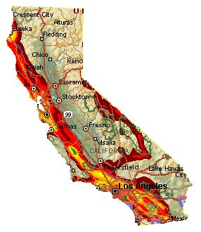
It is often useful to "blank out" unused areas of maps for visual clarity. The US State Mapping Template lets you blank out unused US States or Counties with white shapes, producing clear maps of only your area of interest.
The free download is a demo based on the Nevada area. As you can see, it is not perfect - the labels at the edge of the state are chopped off, unfortunately this is the best you can do with Microsoft MapPoint.
There are a couple steps in creating an individual state map which requires some experience with MapPoint shape objects. To re-create the Nevada map, download the demo template. Type "Nevada, US" in the Find box and hit OK when the dialog comes up. Click in the center of the map, it will select the Nevada shape object (lots of black dots will mark the shape's perimeter). Next, at the bottom in the Drawing toolbar, change the line to black and the fill to "No Fill". That will show the Nevada Map just as it is in the first download. That is it! An alternative is to completely delete the Nevada shape - this is sometimes better if you wish to add pins or annoation in the shape's area.
The Nevada demonstration contains one US State. When you purchase the US State Mapping Template, you will receive a Microsoft MapPoint template file that can be used to produce individual maps for all 50 US States. In addition, Single State Mapper comes with a similar template file that can be used to create maps of individual US counties; plus a template of the Contiguous "Lower 48" US States.