GeoDataSource Cities Database Gold Edition contains city names, feature type classifications, country names in FIPS and ISO, regions, sub-regions, state, county, longitude and latitude in degree and decimal, UTM coordinate grid and JOG reference.
Welcome to the cool cities screensaver! You will traveled through the finest american cities. In this screensaver presented ten animated scenes with amazing sounds and visual effects. It would be the best screensaver that you ever seen!
World countries and cities database with latitude and longitude Countries: 246 States/Regions: 3,576 Cities: 148,638 Database and demo PHP source code included.
3d racing game. Nobody knows exactly what happened, but the fact remains - the hordes of zombies roam in all the cities of our planet. There were madmen among survivors who arrange race through the streets of abandoned cities.
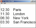
NTP Time Zone Clock to show you the correct local time of 300 cities worldwide. Simply select the cities you want to display the local time and they will be displayed on your desktop.
Top Six Packers and movers give you opportunity to find best packers and movers in your city. Because we give you 6 names of packers and movers in your city, just call to all packers and movers and get best quote from them
The night time transforms the day city landscape to the totally another scene. The night illumination outlights the historical buildings, skyscrapers, roads, trees, etc. and makes the fairy-tale atmosphere in the well-known places.
Desktop weather widget displays current weather conditions and gets forecasts for over 140,000 US cities. It can be placed above or below any window, or attached to the desktop. Size and transparency can be adjusted. Glass window can be added.