|
|
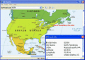
Interactive Flash World Map 1.0
An elegant interactive flash map of the world. This interactive world map includes 165 clickable countries. Display country statistics, country-specific information or mark pinpoint locations. The map uses XML and is easy to customize or install.
free download (864 Kb)
|
|
|
Mobium GPS Navigation System 2.0.232
Mobium GPS is a Navigation System for Windows Mobile PDAs and SmartPhones. With turn-by-turn, GPS guided and voice prompted route guidance you can search over 15 million point of interests. Save big on GAS by searching for the cheapest GAS near you.
free download trial (806 Kb)
|
|
|
Geo Data International Admin 4.00
Geo data international world-wide with towns, town quarters and postal codes. Georeferences as UTM- and geographic coordinates (WGS84) and elevations. Suitable for branch searches, periphery searches and distance computations. dBase, CSV, SDF, SQL.
free download trial (936 Kb)
|
|
|
|
|
FOX Mobile Spy 1.0
Fox Mobile Spy can easily assist mobile phone uses to, backup SMS and Call Records, check all history call numbers and contacts from Mobile Phone.
free download (544 Kb)
|
|
|
Flash for Google Maps DW Extension 1.0.1
Flash Google Maps for Adobe Dreamweaver!
free download trial (827 Kb)
|
|
|
GPSdevTest 1.0.1
GPSdevTest is the Windows application designed as the GPS device diagnostic tool. Main features: COM port (native, mapped USB or Bluetooth ) auto detection for attached device; GPS data logging, statistics, display, etc.
free download (171 Kb)
|
|
|
|
|
ZIP Pointer 2.00
Lookup USA and Canada towns by ZIP, postal code or name and show them on a North American map. It helps you to check customer information, verify postal addresses, and reduce credit card fraud.
free download trial (5.46 Mb)
|
|
|
GeoWatch 1.11
Automatic Geo/GPS location track utility for most parts of the World. Lets you know your and your friends geographic location at all times.
free download trial (2.4 Mb)
|
|
|
ZylGPSReceiver.NET 2.00
ZylGPSReceiver.NET is an event driven .NET component that communicates with a GPS receiver.
free download trial (1.07 Mb)
|
|
|
RoboGEO 5.6.20
Geotag photos from a GPS. Stamp the images or write to the EXIF headers. Export Google Maps, KML KMZ files for Google Earth, Shapefiles (SHP), AutoCAD DXF files, or Flickr. Import from tracklogs, waypoints, GPX or place names.
free download trial (9.28 Mb)
|
|
Pages : 1
| 2
| 3
| 4 | 5
|
|
|
|