|
|
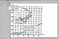
DigitGraph 1.0
The Digit Graph program is meant for the manual digitization of graphic dependences presented as the BMP bitmap images. In concordance with the purpose, the program enables to take point coordinates from the diagram by means of the computer mouse.
free download trial (2.4 Mb)
|
|

|
TOPOWIN 16.03
TOPOWIN is a state-wide register of the German topographic cartographies and of localities with geo references in different coordinate systems. It also is a topographic information system.
free download trial (4.06 Mb)
|
|
|
ORTWIN English 10.00
ORTWIN is a program for the inquiry of localities in Germany. It finds postal zip codes, telephone pre selections, coordinates. It performs perimeter searches and distance calculations. It finds landscapes, natural units, snow- and wind load zones.
free download trial (3.7 Mb)
|
|
|
|
|
|
TOPOWIN English 13.00
TOPOWIN is a state-wide register of the German topographic cartographies and of localities with geo references in different coordinate systems. It also is a topographic information system.
free download trial (3.42 Mb)
|
|

|
Javascript Game Script 1.1
This is a free game engine developed for programming browser based games. It uses Javascript language and CSS to dress up the page. They run pretty reliably together. Use this engine to create your own game.
free download (1.03 Mb)
|
|

|
Javascript Game Engine 1.2
This is a free game engine developed for programming browser based games. It uses Javascript language and CSS to dress up the page. They run pretty reliably together. Use this engine to create your own game.
free download (934 Kb)
|
|
|
|
|
|
?????»????????: ???????µ???‚ ???µ?¶?µ???°?????? 4.12.5
Range: the land surveying Project is a program for the registration of the project of a land surveying of the ground areas made according to requirements, confirmed by the order of Ministry of economic development Russia from August, 3rd, 2011 #388.
free download (5.04 Mb)
|
|

|
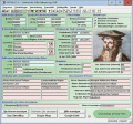
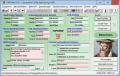
Meet the Team and Biography 1
This takes the Team Member, Meet the Staff type image viewer in a different direction. Given a photo of a group of people, you create rectangles around the people and store the coordinates in an XML file. Then you create a text file about each person
free download trial (4.88 Mb)
|
|
|
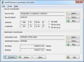
Eye4Software Coordinate Calculator 4.0.5.1120
Eye4Software Coordinate Calculator is a very easy to use tool to perform gps coordinate conversions. Supported projections: Transverse Mercator, Lambert Conformal Conic, UTM, Gauss Kruger, Stereographic, Albers Equal Area, Oblique Mercator and more.
free download trial (8.96 Mb)
|
|
|
VISeismo 2.0
- Alarm level and all last quakes around the place you have selected
- you can select any place at the Earth from the list or add any new places you need for
- the quakes are shown as a radial lines an pies
free download trial (4.56 Mb)
|
|
Pages : 1
| 2
| 3
| 4 | 5
|
|
|
|
