|

|
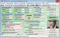
TOPOWIN 16.03
TOPOWIN is a state-wide register of the German topographic cartographies and of localities with geo references in different coordinate systems. It also is a topographic information system.
free download trial (4.06 Mb)
|
|
|
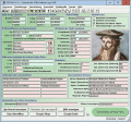
TOPOWIN English 13.00
TOPOWIN is a state-wide register of the German topographic cartographies and of localities with geo references in different coordinate systems. It also is a topographic information system.
free download trial (3.42 Mb)
|
|
|
Terra Excess 25.1217
Terra Excess is land surveying and civil engineering CAD software developed to be extremely intuitive. It can be used for creating topographic plans and maps, calculating stockpile, quarry and earthwork volumes or editing and viewing survey points.
free download trial (32 Mb)
|
|
|
|
|

|
Eye4Gps 2.1
GPS Mapping Software for Windows, Loading topographic maps, manage GPS devices and more. The software can be used with various map formats including: GeoTiff, BSB Nautical Charts, AutoCad DXF files, ESRI Shapefiles.
free download trial (19.03 Mb)
|
|

|
Eye4Gps GPS mapping software 3.0
GPS Mapping Software for Windows, Loading topographic maps, Realtime navigation and more. The software can be used with various map formats including: GeoTiff, OpenStreetMap XML, BSB Nautical Charts, AutoCad DXF files, ESRI Shapefiles and image files
free download trial (8.3 Mb)
|
|

|
Outlook Convert OST Files 6.4
PDS Outlook OST PST conversion can helps you to Outlook convert OST files to PST files easily. Get best method for export Outlook OST to PST which is made by PDS Outlook OST exporter PST program.
free download trial (3.27 Mb)
|
|
|
|
|
|
ORTWIN 13.02
ORTWIN is a program for the inquiry of localities in Germany. It finds postal zip codes, telephone pre selections, coordinates. It performs perimeter searches and distance calculations. It finds landscapes, natural units, snow- and wind load zones.
free download trial (4.36 Mb)
|
|

|
ORTWIN English 10.00
ORTWIN is a program for the inquiry of localities in Germany. It finds postal zip codes, telephone pre selections, coordinates. It performs perimeter searches and distance calculations. It finds landscapes, natural units, snow- and wind load zones.
free download trial (3.7 Mb)
|
|
|
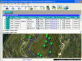
EdiTrail 1.0
Create/Edit/Display/Management/Import/Export Trails/Routes in a simple and flexible environment divided in a data table for the management of trails and a map resulting from numerous providers, (Bing, Arcgis, Ovi, Yahoo, etc).
free download (27.05 Mb)
|
|
|
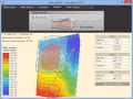
Eye4Software Hydromagic 7.0.15.929
Hydrographic Survey Software for Windows, Load topographic or nautical maps, create singlebeam soundings, generate DTM's (Digital Terrain Models), generate depth contours, generate cross-sections, volume calculations and more.
free download trial (32 Mb)
|
|
Pages : 1
|
|
|
|
