|
|
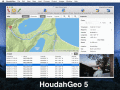
HoudahGeo 4.0.1
One-stop photo geocoding for the Mac: Know where you took that photo. Write geotags to EXIF, XMP & IPTC. See your photos in Google Earth. GPS device optional. Use with iPhoto, Aperture or Lightroom
free download trial (17.64 Mb)
|
|

|
DRAGSENS 1.01
DRAGSENS Geo Software is used for the exact position estimation of a towed body, sensor, camera, array or net, dragged behind a ship, aircraft or vehicle. The software allows a real-time estimation of the position of a dragged sensor.
free download trial (1.76 Mb)
|
|

|
Graph Earth 0.9.5
Visualize your data in 3D! Quick, easy and inexpensive. Graph Earth enables business professionals to create stunning visual representations of their data, all without the time and costs associated with a full-feature GIS.
free download trial (469 Kb)
|
|
|
|
|

|
OkCustomMap 1.0.0
OkCustomMap is a software to produce Garmin Custom Maps. Supports many map formats, JPEG quality, KML transparency, draw order, image scaling and filters. You can customize the size of the tiles or the tiles number horizzontally or vertically.
free download (3.22 Mb)
|
|

|
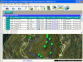
OkMap 8.8.3
OkMap is a software that works with vectorial and raster maps that you have bought or scanned. OkMap lets you organize paths by creating waypoints, routes and tracks, and upload/download data to/from your GPS. OkMap supports GPS real-time navigation.
free download (20.21 Mb)
|
|
|
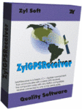
ZylGPSReceiver Mobile 1.50
ZylGPSReceiver Mobile is an event driven Compact Framework.NET component that communicates with a GPS receiver.
It is designed for mobile devices such as PDAs, which run on Windows Mobile (CE) operating systems.
free download trial (551 Kb)
|
|
|
|
|

|
Eye4Software GPS Toolkit 2.4
Toolkit to add GPS functionality to software (GPS SDK). All NMEA0183 protocol versions are supported, Garmin USB PVT support. Support for datum conversions and coordinate conversion using different map projections.
free download trial (595 Kb)
|
|
|
EdiTrail 1.0
Create/Edit/Display/Management/Import/Export Trails/Routes in a simple and flexible environment divided in a data table for the management of trails and a map resulting from numerous providers, (Bing, Arcgis, Ovi, Yahoo, etc).
free download (27.05 Mb)
|
|

|
GPS.NET 2.3.20
Develop precise, efficient, and reliable GPS software in record time with this multithreaded component for desktop and mobile devices, including PocketPC, Windows CE, Tablet PC, Smartphone and Windows Mobile!
free download trial (10.53 Mb)
|
|
|
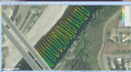
Eye4Software Hydromagic 7.0.15.929
Hydrographic Survey Software for Windows, Load topographic or nautical maps, create singlebeam soundings, generate DTM's (Digital Terrain Models), generate depth contours, generate cross-sections, volume calculations and more.
free download trial (32 Mb)
|
|
Pages : 1
| 2
| 3 | 4
|
|
|
|
