|
|
Geodata International 9.03
Geodata International - World-wide database of countries with georeferenced towns, municipalities, postal codes and administrative units with WGS84 and UTM coordinates and elevations for geocoding, proximity search, navigation, distance calculation.
free download trial (1.97 Mb)
|
|

|
Bing Satellite Superget Downloader 6.12.3
Bing Map SuperGet is a smart tool which can help you download Bing satellite images from Bing fast and stably.
free download trial (3.4 Mb)
|
|
|
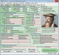
ORTWIN 13.02
ORTWIN is a program for the inquiry of localities in Germany. It finds postal zip codes, telephone pre selections, coordinates. It performs perimeter searches and distance calculations. It finds landscapes, natural units, snow- and wind load zones.
free download trial (4.36 Mb)
|
|
|
|
|
|
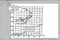
DigitGraph 1.0
The Digit Graph program is meant for the manual digitization of graphic dependences presented as the BMP bitmap images. In concordance with the purpose, the program enables to take point coordinates from the diagram by means of the computer mouse.
free download trial (2.4 Mb)
|
|

|
Bing Maps Superget Downloader 6.12.100
Bing Maps Superget Downloader is a smart tool which can help you download Bing map images from Bing fast and stably.
free download trial (3.41 Mb)
|
|
|
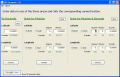
GPS Converter 1.0
GPS Converter will convert GPS coordinates between three different formats: 34.26965, -116.76783; N 34?° 16.179', W 116?° 46.07'; and N 34?° 16' 10.74", W 116?° 46' 4.2". Will map the results in Google Maps.
free download (929 Kb)
|
|
|
|
|

|
Arceyes Google Satellite Downloader 6.07.133
Arceyes Google Satellite Downloader is a smart tool which can help you download tile satellite images from google map fastly and stably.
free download trial (4.7 Mb)
|
|
|
TOPOWIN 16.03
TOPOWIN is a state-wide register of the German topographic cartographies and of localities with geo references in different coordinate systems. It also is a topographic information system.
free download trial (4.06 Mb)
|
|

|
Maps Downloader For Google Satellite 7.16.145
Maps Downloader For Google Satellite is a smart tool which can help you download tile satellite images from google map fastly and stably.
free download trial (4.74 Mb)
|
|

|
ORTWIN English 10.00
ORTWIN is a program for the inquiry of localities in Germany. It finds postal zip codes, telephone pre selections, coordinates. It performs perimeter searches and distance calculations. It finds landscapes, natural units, snow- and wind load zones.
free download trial (3.7 Mb)
|
|
Pages : 1
| 2
| 3
| 4 | 5
|
|
|
|
