|
|
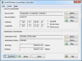
Eye4Software Coordinate Calculator 4.0.5.1120
Eye4Software Coordinate Calculator is a very easy to use tool to perform gps coordinate conversions. Supported projections: Transverse Mercator, Lambert Conformal Conic, UTM, Gauss Kruger, Stereographic, Albers Equal Area, Oblique Mercator and more.
free download trial (8.96 Mb)
|
|
|
BetaDLL 2.01
BetaDLL contains precise functions for coordinate transformations and datum shifts using the German NTv2 standard BeTA2007. The Functions of the 32 bit / 64 bit DLL can be easy called from own applications.
free download trial (1020 Kb)
|
|

|
DRAGSENS 1.01
DRAGSENS Geo Software is used for the exact position estimation of a towed body, sensor, camera, array or net, dragged behind a ship, aircraft or vehicle. The software allows a real-time estimation of the position of a dragged sensor.
free download trial (1.76 Mb)
|
|
|
|
|
|
EdiTrail 1.0
Create/Edit/Display/Management/Import/Export Trails/Routes in a simple and flexible environment divided in a data table for the management of trails and a map resulting from numerous providers, (Bing, Arcgis, Ovi, Yahoo, etc).
free download (27.05 Mb)
|
|

|
GeoDataSource World Cities Database (Gold Edition) November.2010
GeoDataSource Cities Database Gold Edition contains city names, feature type classifications, country names in FIPS and ISO, regions, sub-regions, state, county, longitude and latitude in degree and decimal, UTM coordinate grid and JOG reference.
free download trial (164 Kb)
|
|

|
TOPOWIN 16.03
TOPOWIN is a state-wide register of the German topographic cartographies and of localities with geo references in different coordinate systems. It also is a topographic information system.
free download trial (4.06 Mb)
|
|
|
|
|
|
TOPOWIN English 13.00
TOPOWIN is a state-wide register of the German topographic cartographies and of localities with geo references in different coordinate systems. It also is a topographic information system.
free download trial (3.42 Mb)
|
|

|
Eye4Software GPS Toolkit 2.4
Toolkit to add GPS functionality to software (GPS SDK). All NMEA0183 protocol versions are supported, Garmin USB PVT support. Support for datum conversions and coordinate conversion using different map projections.
free download trial (595 Kb)
|
|

|
SEVENPAR (English) 2.00
SEVENPAR calculaties exact parameter sets for the Spatial Helmert or Molodensky Transformation with seven or three parameters, which are used for accurate geodetic datum shifts between different reference systems for coordinate transformations.
free download trial (2.48 Mb)
|
|
|
SEVENPAR 7.02
SEVENPAR calculaties exact parameter sets for the Spatial Helmert or Molodensky Transformation with seven or three parameters, which are used for accurate geodetic datum shifts between different reference systems for coordinate transformations.
free download trial (2.24 Mb)
|
|
Pages : 1
| 2 | 3
|
|
|
|
